

Severe Storms Bring Flooding, Downed Trees and Damaging Winds to Chicago Area
Chicago
Published · Updated

Watch Live Videos
Download Citizen




Summary
- Severe thunderstorms are moving across the Chicago area Monday, bringing destructive winds, large hail, heavy downpours and multiple tornado warnings.
- A tornado warning was issued for eastern DuPage County until 12:45 p.m. after a storm capable of producing a tornado was spotted over Glen Ellyn, possibly producing a brief tornado, moving south at 30 mph toward Naperville, Wheaton, Downers Grove, and Bolingbrook.
- Severe thunderstorm warnings are in effect for Will, Cook, Kane, DuPage, Lake and McHenry counties, with wind gusts up to 70 mph and golf ball-size hail possible. Affected areas include Chicago, Aurora, Naperville, Cicero, Schaumburg, O'Hare Airport, Oak Park, and Calumet City.
- An Extreme Heat Warning is also in effect for parts of the Chicago area through 9 p.m. Monday, with heat index values reaching 100 to 110. A second round of storms is possible around 6 p.m., pushing south into northwest Indiana.
- Residents in warned areas should move to an interior room on the lowest floor of a sturdy building, away from windows. Flying debris can be dangerous and mobile homes may be damaged or destroyed.
Timeline
Firefighters continue to investigate smoke coming from a residential building during heavy rain.
A utility truck is clearing debris while traffic moves slowly on a heavily flooded residential street.
Firefighters continue to investigate smoke coming from a residential building during heavy rain.
Heavy rain continues on residential streets, maintaining hazardous wet and flooded conditions.
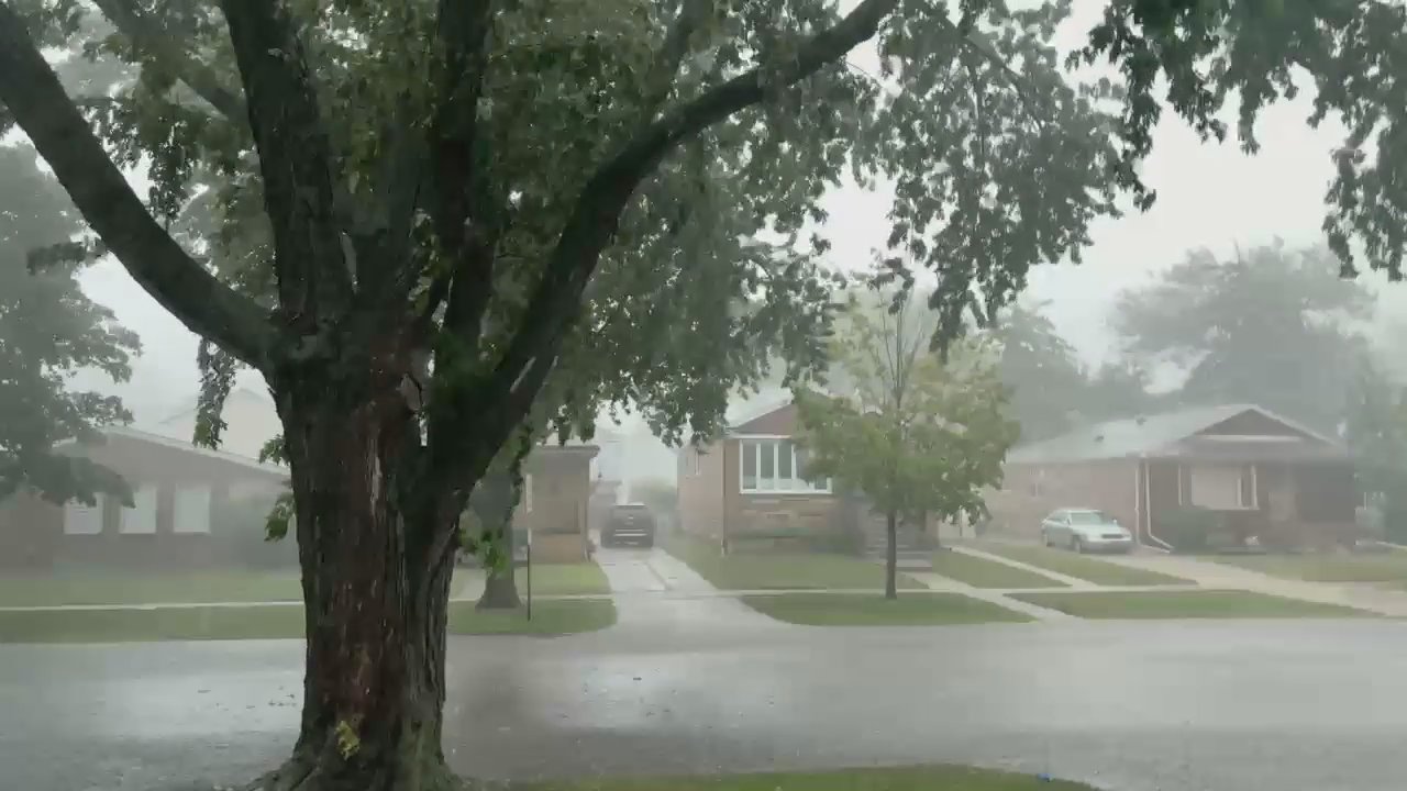
Heavy rain and fog persist, reducing visibility across the cityscape with buildings and trees.
Firefighters continue investigating smoke rising from a residential building amid heavy rain.
Firefighters are investigating smoke coming from a residential building amid ongoing storm conditions.
Heavy rain continues on residential streets as various vehicles drive through wet conditions.
A fallen tree blocks several residential streets, forcing vehicles to navigate around the obstruction.
The address reported for this incident has changed to Chicago.
No injuries have been reported as of this update.
Floodwaters have also submerged vehicles and signs across Chicago and the suburbs.
Additional user videos show streets inundated with water, while others show downed tree limbs and branches across the city.
Heavy rainfall continues to flood residential streets, creating puddles around parked cars.
Heavy rain continues to fall on city streets, maintaining hazardous road conditions.
Rain continues steadily, maintaining wet and hazardous road conditions in the area.
A person guides a red sedan through fog using gestures and a flashlight.
Trees have fallen onto power lines, causing disruptions to traffic and power supply.
A vehicle drives through heavy rain with reduced visibility on a residential street.
Traffic is moving smoothly on the highway despite ongoing cloudy conditions.
A fallen tree is blocking a road, affecting traffic movement.
A vehicle is driving through heavy rain on a wet residential street with parked cars and trees.
Fog and heavy rain continue to reduce visibility across the residential neighborhood.
Heavy rain and fog continue to reduce visibility on streets and intersections.
Firefighters are investigating smoke rising from a residential building amid continued rain.
Smoke is visible from a residence on the rainy residential street with parked vehicles.
Heavy rainfall continues to flood residential streets, sidewalks, and yards.
Heavy rain persists in the residential area, maintaining reduced visibility and wet street conditions.
The NWS has canceled the Severe Thunderstorm Warning.
Heavy rain and strong winds continue to affect the residential street, causing flooding and swaying trees.
Heavy rain continues on residential streets, reducing visibility and causing misty conditions.
Flooding worsens on residential street with vehicles moving through water and rising steam observed.
Flooding has submerged one sedan and damaged another on a residential street during heavy rain.
CORRECTION: There are no homes on fire due to the severe weather.
Vehicles navigate through flooded, obstacle-filled streets amid heavy rain at a busy intersection.
Vehicles continue to drive slowly on residential streets amid heavy rain and poor visibility.
Heavy rain and strong winds continue as trees sway and vehicles remain parked in the area.
The severe storms have prompted a ground stop at O'Hare International and Midway International Airports, according to Samdesk sources.
Firefighters are responding to a building fire amid ongoing severe storm conditions.
Strong winds and heavy rain cause trees to sway and power lines to stretch, reducing visibility.
Residents in warned areas should move to an interior room on the lowest floor of a sturdy building, away from windows. Flying debris can be dangerous and mobile homes may be damaged or destroyed.
A second round of storms is possible around 6 p.m., developing to the north before pushing south into northwest Indiana. A severe thunderstorm watch covers the entire Chicago area, including northwest Indiana, through 8 p.m.
An Extreme Heat Warning is in effect for parts of the Chicago area through 9 p.m. Monday, with heat index values expected to reach 100 to 110 degrees.
Severe thunderstorm warnings are in effect for Will, Cook, Kane, DuPage, Lake and McHenry counties through the afternoon, with wind gusts up to 70 mph and golf ball-size hail possible. Affected areas include Chicago, Aurora, Naperville, Schaumburg, O'Hare Airport, and Calumet City.
A tornado warning was issued for eastern DuPage County until 12:45 p.m. Monday after a storm capable of producing a tornado was spotted over Glen Ellyn, possibly already producing a brief tornado. The storm was moving south at 30 mph toward Naperville, Wheaton, Downers Grove, Bolingbrook, and Lemont.
Heavy rainfall continues to reduce visibility in the area.
A fire truck and utility worker are directing traffic through foggy, wet roundabouts.
Cars continue to move slowly on wet roads amid ongoing heavy rain and overcast skies.
A fallen tree is blocking a road, forcing vehicles to navigate around the obstruction.
Vehicles continue to navigate wet roads and roundabouts through heavy rain and fog.
A vehicle is stranded in floodwaters during the severe thunderstorm.
Smoke is rising from a building during the ongoing severe thunderstorm.
Light smoke is visible rising from trees amid windy conditions during the storm.
Heavy rain continues to impact the residential area, affecting visibility and road conditions.
Vehicles are leaving the area as weather conditions continue to affect the neighborhood.
Heavy rain is causing wet road conditions on the highway.
The National Weather Service (NWS) has issued a Severe Thunderstorm Warning that is projected to last until 1:00 p.m.
Incident reported at Cook, DuPage, and Will IL.
Firefighters continue to investigate smoke coming from a residential building during heavy rain.
A utility truck is clearing debris while traffic moves slowly on a heavily flooded residential street.
Firefighters continue to investigate smoke coming from a residential building during heavy rain.
Heavy rain continues on residential streets, maintaining hazardous wet and flooded conditions.
Heavy rain and fog persist, reducing visibility across the cityscape with buildings and trees.
Firefighters continue investigating smoke rising from a residential building amid heavy rain.
Firefighters are investigating smoke coming from a residential building amid ongoing storm conditions.
Heavy rain continues on residential streets as various vehicles drive through wet conditions.
A fallen tree blocks several residential streets, forcing vehicles to navigate around the obstruction.
The address reported for this incident has changed to Chicago.
No injuries have been reported as of this update.
Floodwaters have also submerged vehicles and signs across Chicago and the suburbs.
Additional user videos show streets inundated with water, while others show downed tree limbs and branches across the city.
Heavy rainfall continues to flood residential streets, creating puddles around parked cars.
Heavy rain continues to fall on city streets, maintaining hazardous road conditions.
Rain continues steadily, maintaining wet and hazardous road conditions in the area.
A person guides a red sedan through fog using gestures and a flashlight.
Trees have fallen onto power lines, causing disruptions to traffic and power supply.
A vehicle drives through heavy rain with reduced visibility on a residential street.
Traffic is moving smoothly on the highway despite ongoing cloudy conditions.
A fallen tree is blocking a road, affecting traffic movement.
A vehicle is driving through heavy rain on a wet residential street with parked cars and trees.
Fog and heavy rain continue to reduce visibility across the residential neighborhood.
Heavy rain and fog continue to reduce visibility on streets and intersections.
Firefighters are investigating smoke rising from a residential building amid continued rain.
Smoke is visible from a residence on the rainy residential street with parked vehicles.
Heavy rainfall continues to flood residential streets, sidewalks, and yards.
Heavy rain persists in the residential area, maintaining reduced visibility and wet street conditions.
The NWS has canceled the Severe Thunderstorm Warning.
Heavy rain and strong winds continue to affect the residential street, causing flooding and swaying trees.
Heavy rain continues on residential streets, reducing visibility and causing misty conditions.
Flooding worsens on residential street with vehicles moving through water and rising steam observed.
Flooding has submerged one sedan and damaged another on a residential street during heavy rain.
CORRECTION: There are no homes on fire due to the severe weather.
Vehicles navigate through flooded, obstacle-filled streets amid heavy rain at a busy intersection.
Vehicles continue to drive slowly on residential streets amid heavy rain and poor visibility.
Heavy rain and strong winds continue as trees sway and vehicles remain parked in the area.
The severe storms have prompted a ground stop at O'Hare International and Midway International Airports, according to Samdesk sources.
Firefighters are responding to a building fire amid ongoing severe storm conditions.
Strong winds and heavy rain cause trees to sway and power lines to stretch, reducing visibility.
Residents in warned areas should move to an interior room on the lowest floor of a sturdy building, away from windows. Flying debris can be dangerous and mobile homes may be damaged or destroyed.
A second round of storms is possible around 6 p.m., developing to the north before pushing south into northwest Indiana. A severe thunderstorm watch covers the entire Chicago area, including northwest Indiana, through 8 p.m.
An Extreme Heat Warning is in effect for parts of the Chicago area through 9 p.m. Monday, with heat index values expected to reach 100 to 110 degrees.
Severe thunderstorm warnings are in effect for Will, Cook, Kane, DuPage, Lake and McHenry counties through the afternoon, with wind gusts up to 70 mph and golf ball-size hail possible. Affected areas include Chicago, Aurora, Naperville, Schaumburg, O'Hare Airport, and Calumet City.
A tornado warning was issued for eastern DuPage County until 12:45 p.m. Monday after a storm capable of producing a tornado was spotted over Glen Ellyn, possibly already producing a brief tornado. The storm was moving south at 30 mph toward Naperville, Wheaton, Downers Grove, Bolingbrook, and Lemont.
Heavy rainfall continues to reduce visibility in the area.
A fire truck and utility worker are directing traffic through foggy, wet roundabouts.
Cars continue to move slowly on wet roads amid ongoing heavy rain and overcast skies.
A fallen tree is blocking a road, forcing vehicles to navigate around the obstruction.
Vehicles continue to navigate wet roads and roundabouts through heavy rain and fog.
A vehicle is stranded in floodwaters during the severe thunderstorm.
Smoke is rising from a building during the ongoing severe thunderstorm.
Light smoke is visible rising from trees amid windy conditions during the storm.
Heavy rain continues to impact the residential area, affecting visibility and road conditions.
Vehicles are leaving the area as weather conditions continue to affect the neighborhood.
Heavy rain is causing wet road conditions on the highway.
The National Weather Service (NWS) has issued a Severe Thunderstorm Warning that is projected to last until 1:00 p.m.
Incident reported at Cook, DuPage, and Will IL.
Firefighters continue to investigate smoke coming from a residential building during heavy rain.
A utility truck is clearing debris while traffic moves slowly on a heavily flooded residential street.
Firefighters continue to investigate smoke coming from a residential building during heavy rain.
Heavy rain continues on residential streets, maintaining hazardous wet and flooded conditions.
Heavy rain and fog persist, reducing visibility across the cityscape with buildings and trees.
Firefighters continue investigating smoke rising from a residential building amid heavy rain.
Firefighters are investigating smoke coming from a residential building amid ongoing storm conditions.
Heavy rain continues on residential streets as various vehicles drive through wet conditions.
A fallen tree blocks several residential streets, forcing vehicles to navigate around the obstruction.
The address reported for this incident has changed to Chicago.
No injuries have been reported as of this update.
Floodwaters have also submerged vehicles and signs across Chicago and the suburbs.
Additional user videos show streets inundated with water, while others show downed tree limbs and branches across the city.
Heavy rainfall continues to flood residential streets, creating puddles around parked cars.
Heavy rain continues to fall on city streets, maintaining hazardous road conditions.
Rain continues steadily, maintaining wet and hazardous road conditions in the area.
A person guides a red sedan through fog using gestures and a flashlight.
Trees have fallen onto power lines, causing disruptions to traffic and power supply.
A vehicle drives through heavy rain with reduced visibility on a residential street.
Traffic is moving smoothly on the highway despite ongoing cloudy conditions.
A fallen tree is blocking a road, affecting traffic movement.
A vehicle is driving through heavy rain on a wet residential street with parked cars and trees.
Fog and heavy rain continue to reduce visibility across the residential neighborhood.
Heavy rain and fog continue to reduce visibility on streets and intersections.
Firefighters are investigating smoke rising from a residential building amid continued rain.
Smoke is visible from a residence on the rainy residential street with parked vehicles.
Heavy rainfall continues to flood residential streets, sidewalks, and yards.
Heavy rain persists in the residential area, maintaining reduced visibility and wet street conditions.
The NWS has canceled the Severe Thunderstorm Warning.
Heavy rain and strong winds continue to affect the residential street, causing flooding and swaying trees.
Heavy rain continues on residential streets, reducing visibility and causing misty conditions.
Flooding worsens on residential street with vehicles moving through water and rising steam observed.
Flooding has submerged one sedan and damaged another on a residential street during heavy rain.
CORRECTION: There are no homes on fire due to the severe weather.
Vehicles navigate through flooded, obstacle-filled streets amid heavy rain at a busy intersection.
Vehicles continue to drive slowly on residential streets amid heavy rain and poor visibility.
Heavy rain and strong winds continue as trees sway and vehicles remain parked in the area.
The severe storms have prompted a ground stop at O'Hare International and Midway International Airports, according to Samdesk sources.
Firefighters are responding to a building fire amid ongoing severe storm conditions.
Strong winds and heavy rain cause trees to sway and power lines to stretch, reducing visibility.
Residents in warned areas should move to an interior room on the lowest floor of a sturdy building, away from windows. Flying debris can be dangerous and mobile homes may be damaged or destroyed.
A second round of storms is possible around 6 p.m., developing to the north before pushing south into northwest Indiana. A severe thunderstorm watch covers the entire Chicago area, including northwest Indiana, through 8 p.m.
An Extreme Heat Warning is in effect for parts of the Chicago area through 9 p.m. Monday, with heat index values expected to reach 100 to 110 degrees.
Severe thunderstorm warnings are in effect for Will, Cook, Kane, DuPage, Lake and McHenry counties through the afternoon, with wind gusts up to 70 mph and golf ball-size hail possible. Affected areas include Chicago, Aurora, Naperville, Schaumburg, O'Hare Airport, and Calumet City.
A tornado warning was issued for eastern DuPage County until 12:45 p.m. Monday after a storm capable of producing a tornado was spotted over Glen Ellyn, possibly already producing a brief tornado. The storm was moving south at 30 mph toward Naperville, Wheaton, Downers Grove, Bolingbrook, and Lemont.
Heavy rainfall continues to reduce visibility in the area.
A fire truck and utility worker are directing traffic through foggy, wet roundabouts.
Cars continue to move slowly on wet roads amid ongoing heavy rain and overcast skies.
A fallen tree is blocking a road, forcing vehicles to navigate around the obstruction.
Vehicles continue to navigate wet roads and roundabouts through heavy rain and fog.
A vehicle is stranded in floodwaters during the severe thunderstorm.
Smoke is rising from a building during the ongoing severe thunderstorm.
Light smoke is visible rising from trees amid windy conditions during the storm.
Heavy rain continues to impact the residential area, affecting visibility and road conditions.
Vehicles are leaving the area as weather conditions continue to affect the neighborhood.
Heavy rain is causing wet road conditions on the highway.
The National Weather Service (NWS) has issued a Severe Thunderstorm Warning that is projected to last until 1:00 p.m.
Incident reported at Cook, DuPage, and Will IL.
Firefighters continue to investigate smoke coming from a residential building during heavy rain.
A utility truck is clearing debris while traffic moves slowly on a heavily flooded residential street.
Firefighters continue to investigate smoke coming from a residential building during heavy rain.
Heavy rain continues on residential streets, maintaining hazardous wet and flooded conditions.
Heavy rain and fog persist, reducing visibility across the cityscape with buildings and trees.
Firefighters continue investigating smoke rising from a residential building amid heavy rain.
Firefighters are investigating smoke coming from a residential building amid ongoing storm conditions.
Heavy rain continues on residential streets as various vehicles drive through wet conditions.
A fallen tree blocks several residential streets, forcing vehicles to navigate around the obstruction.
The address reported for this incident has changed to Chicago.
No injuries have been reported as of this update.
Floodwaters have also submerged vehicles and signs across Chicago and the suburbs.
Additional user videos show streets inundated with water, while others show downed tree limbs and branches across the city.
Heavy rainfall continues to flood residential streets, creating puddles around parked cars.
Heavy rain continues to fall on city streets, maintaining hazardous road conditions.
Rain continues steadily, maintaining wet and hazardous road conditions in the area.
A person guides a red sedan through fog using gestures and a flashlight.
Trees have fallen onto power lines, causing disruptions to traffic and power supply.
A vehicle drives through heavy rain with reduced visibility on a residential street.
Traffic is moving smoothly on the highway despite ongoing cloudy conditions.
A fallen tree is blocking a road, affecting traffic movement.
A vehicle is driving through heavy rain on a wet residential street with parked cars and trees.
Fog and heavy rain continue to reduce visibility across the residential neighborhood.
Heavy rain and fog continue to reduce visibility on streets and intersections.
Firefighters are investigating smoke rising from a residential building amid continued rain.
Smoke is visible from a residence on the rainy residential street with parked vehicles.
Heavy rainfall continues to flood residential streets, sidewalks, and yards.
Heavy rain persists in the residential area, maintaining reduced visibility and wet street conditions.
The NWS has canceled the Severe Thunderstorm Warning.
Heavy rain and strong winds continue to affect the residential street, causing flooding and swaying trees.
Heavy rain continues on residential streets, reducing visibility and causing misty conditions.
Flooding worsens on residential street with vehicles moving through water and rising steam observed.
Flooding has submerged one sedan and damaged another on a residential street during heavy rain.
CORRECTION: There are no homes on fire due to the severe weather.
Vehicles navigate through flooded, obstacle-filled streets amid heavy rain at a busy intersection.
Vehicles continue to drive slowly on residential streets amid heavy rain and poor visibility.
Heavy rain and strong winds continue as trees sway and vehicles remain parked in the area.
The severe storms have prompted a ground stop at O'Hare International and Midway International Airports, according to Samdesk sources.
Firefighters are responding to a building fire amid ongoing severe storm conditions.
Strong winds and heavy rain cause trees to sway and power lines to stretch, reducing visibility.
Residents in warned areas should move to an interior room on the lowest floor of a sturdy building, away from windows. Flying debris can be dangerous and mobile homes may be damaged or destroyed.
A second round of storms is possible around 6 p.m., developing to the north before pushing south into northwest Indiana. A severe thunderstorm watch covers the entire Chicago area, including northwest Indiana, through 8 p.m.
An Extreme Heat Warning is in effect for parts of the Chicago area through 9 p.m. Monday, with heat index values expected to reach 100 to 110 degrees.
Severe thunderstorm warnings are in effect for Will, Cook, Kane, DuPage, Lake and McHenry counties through the afternoon, with wind gusts up to 70 mph and golf ball-size hail possible. Affected areas include Chicago, Aurora, Naperville, Schaumburg, O'Hare Airport, and Calumet City.
A tornado warning was issued for eastern DuPage County until 12:45 p.m. Monday after a storm capable of producing a tornado was spotted over Glen Ellyn, possibly already producing a brief tornado. The storm was moving south at 30 mph toward Naperville, Wheaton, Downers Grove, Bolingbrook, and Lemont.
Heavy rainfall continues to reduce visibility in the area.
A fire truck and utility worker are directing traffic through foggy, wet roundabouts.
Cars continue to move slowly on wet roads amid ongoing heavy rain and overcast skies.
A fallen tree is blocking a road, forcing vehicles to navigate around the obstruction.
Vehicles continue to navigate wet roads and roundabouts through heavy rain and fog.
A vehicle is stranded in floodwaters during the severe thunderstorm.
Smoke is rising from a building during the ongoing severe thunderstorm.
Light smoke is visible rising from trees amid windy conditions during the storm.
Heavy rain continues to impact the residential area, affecting visibility and road conditions.
Vehicles are leaving the area as weather conditions continue to affect the neighborhood.
Heavy rain is causing wet road conditions on the highway.
The National Weather Service (NWS) has issued a Severe Thunderstorm Warning that is projected to last until 1:00 p.m.
Incident reported at Cook, DuPage, and Will IL.
Firefighters continue to investigate smoke coming from a residential building during heavy rain.
A utility truck is clearing debris while traffic moves slowly on a heavily flooded residential street.
Firefighters continue to investigate smoke coming from a residential building during heavy rain.
Heavy rain continues on residential streets, maintaining hazardous wet and flooded conditions.
Heavy rain and fog persist, reducing visibility across the cityscape with buildings and trees.
Firefighters continue investigating smoke rising from a residential building amid heavy rain.
Firefighters are investigating smoke coming from a residential building amid ongoing storm conditions.
Heavy rain continues on residential streets as various vehicles drive through wet conditions.
A fallen tree blocks several residential streets, forcing vehicles to navigate around the obstruction.
The address reported for this incident has changed to Chicago.
No injuries have been reported as of this update.
Floodwaters have also submerged vehicles and signs across Chicago and the suburbs.
Additional user videos show streets inundated with water, while others show downed tree limbs and branches across the city.
Heavy rainfall continues to flood residential streets, creating puddles around parked cars.
Heavy rain continues to fall on city streets, maintaining hazardous road conditions.
Rain continues steadily, maintaining wet and hazardous road conditions in the area.
A person guides a red sedan through fog using gestures and a flashlight.
Trees have fallen onto power lines, causing disruptions to traffic and power supply.
A vehicle drives through heavy rain with reduced visibility on a residential street.
Traffic is moving smoothly on the highway despite ongoing cloudy conditions.
A fallen tree is blocking a road, affecting traffic movement.
A vehicle is driving through heavy rain on a wet residential street with parked cars and trees.
Fog and heavy rain continue to reduce visibility across the residential neighborhood.
Heavy rain and fog continue to reduce visibility on streets and intersections.
Firefighters are investigating smoke rising from a residential building amid continued rain.
Smoke is visible from a residence on the rainy residential street with parked vehicles.
Heavy rainfall continues to flood residential streets, sidewalks, and yards.
Heavy rain persists in the residential area, maintaining reduced visibility and wet street conditions.
The NWS has canceled the Severe Thunderstorm Warning.
Heavy rain and strong winds continue to affect the residential street, causing flooding and swaying trees.
Heavy rain continues on residential streets, reducing visibility and causing misty conditions.
Flooding worsens on residential street with vehicles moving through water and rising steam observed.
Flooding has submerged one sedan and damaged another on a residential street during heavy rain.
CORRECTION: There are no homes on fire due to the severe weather.
Vehicles navigate through flooded, obstacle-filled streets amid heavy rain at a busy intersection.
Vehicles continue to drive slowly on residential streets amid heavy rain and poor visibility.
Heavy rain and strong winds continue as trees sway and vehicles remain parked in the area.
The severe storms have prompted a ground stop at O'Hare International and Midway International Airports, according to Samdesk sources.
Firefighters are responding to a building fire amid ongoing severe storm conditions.
Strong winds and heavy rain cause trees to sway and power lines to stretch, reducing visibility.
Residents in warned areas should move to an interior room on the lowest floor of a sturdy building, away from windows. Flying debris can be dangerous and mobile homes may be damaged or destroyed.
A second round of storms is possible around 6 p.m., developing to the north before pushing south into northwest Indiana. A severe thunderstorm watch covers the entire Chicago area, including northwest Indiana, through 8 p.m.
An Extreme Heat Warning is in effect for parts of the Chicago area through 9 p.m. Monday, with heat index values expected to reach 100 to 110 degrees.
Severe thunderstorm warnings are in effect for Will, Cook, Kane, DuPage, Lake and McHenry counties through the afternoon, with wind gusts up to 70 mph and golf ball-size hail possible. Affected areas include Chicago, Aurora, Naperville, Schaumburg, O'Hare Airport, and Calumet City.
A tornado warning was issued for eastern DuPage County until 12:45 p.m. Monday after a storm capable of producing a tornado was spotted over Glen Ellyn, possibly already producing a brief tornado. The storm was moving south at 30 mph toward Naperville, Wheaton, Downers Grove, Bolingbrook, and Lemont.
Heavy rainfall continues to reduce visibility in the area.
A fire truck and utility worker are directing traffic through foggy, wet roundabouts.
Cars continue to move slowly on wet roads amid ongoing heavy rain and overcast skies.
A fallen tree is blocking a road, forcing vehicles to navigate around the obstruction.
Vehicles continue to navigate wet roads and roundabouts through heavy rain and fog.
A vehicle is stranded in floodwaters during the severe thunderstorm.
Smoke is rising from a building during the ongoing severe thunderstorm.
Light smoke is visible rising from trees amid windy conditions during the storm.
Heavy rain continues to impact the residential area, affecting visibility and road conditions.
Vehicles are leaving the area as weather conditions continue to affect the neighborhood.
Heavy rain is causing wet road conditions on the highway.
The National Weather Service (NWS) has issued a Severe Thunderstorm Warning that is projected to last until 1:00 p.m.
Incident reported at Cook, DuPage, and Will IL.
Stay up-to-date
Download CitizenComments30

Perfect timing for a blunt on the porch

@Sosaa300 LoL..Right!! 🤣 “Hey does it seem a little windy out today??”

and people will still deny climate change smh.

Climate change IS real! It gets hot in summer and cold in winter. Astonishing

Sending prayers up. Philly got hit bad on July 16th with Microbursts
Really bad weather in many states whether heat advisories or flooding.
Perfect timing for a blunt on the porch
@Sosaa300 LoL..Right!! 🤣 “Hey does it seem a little windy out today??”
and people will still deny climate change smh.
Climate change IS real! It gets hot in summer and cold in winter. Astonishing
Sending prayers up. Philly got hit bad on July 16th with Microbursts
Really bad weather in many states whether heat advisories or flooding.
Perfect timing for a blunt on the porch
@Sosaa300 LoL..Right!! 🤣 “Hey does it seem a little windy out today??”
and people will still deny climate change smh.
Climate change IS real! It gets hot in summer and cold in winter. Astonishing
Sending prayers up. Philly got hit bad on July 16th with Microbursts
Really bad weather in many states whether heat advisories or flooding.
Perfect timing for a blunt on the porch
@Sosaa300 LoL..Right!! 🤣 “Hey does it seem a little windy out today??”
and people will still deny climate change smh.
Climate change IS real! It gets hot in summer and cold in winter. Astonishing
Sending prayers up. Philly got hit bad on July 16th with Microbursts
Really bad weather in many states whether heat advisories or flooding.
Stay informed on local incidents
Download Citizen



Perfect timing for a blunt on the porch
@Sosaa300 LoL..Right!! 🤣 “Hey does it seem a little windy out today??”
and people will still deny climate change smh.
Climate change IS real! It gets hot in summer and cold in winter. Astonishing
Sending prayers up. Philly got hit bad on July 16th with Microbursts
Really bad weather in many states whether heat advisories or flooding.